Emerita Intersects 32.6 Meters Grading 0.2 % Copper; 1.9 % Lead; 4.1 % Zinc; 4.01 g/t Gold and 84.1 g/t Silver; including 3.5 M grading 0.1 % Copper; 2.3 % Lead; 3.4 % Zinc; 7.07 g/t Gold and 99.9 g/t Silver from 138.9 Meters
TORONTO, April 04, 2023 (GLOBE NEWSWIRE) -- Emerita Resources Corp. (TSX – V: EMO; OTCQB: EMOTF; FSE: LLJA) (the “Company” or “Emerita”) is pleased to announce additional assay results from the ongoing 2022 - 2023 delineation drilling program at La Romanera Deposit, part of Emerita’s wholly owned Iberian Belt West Project (“IBW” or the “Project”). Assays from 15 additional drill holes from La Romanera deposit and 7 holes from La Infanta deposit have been received. IBW hosts three previously identified massive sulphide deposits: La Infanta, La Romanera and El Cura. All deposits are open for expansion along strike and at depth.
According to Joaquin Merino, P.Geo., President of Emerita, “We are closing in on the final drill hole assays required for the initial NI 43-101 mineral resource estimate for the Iberian Belt West Project. The work is ongoing and is expected to be completed around the end of April. Drilling continues to expand the deposit, however we are reducing the number of rigs as we complete the delineation drilling phase and focus the ongoing drill program on the resource expansion.”
La Romanera assay results include holes LR029, LR067, LR069, LR076, LR078, LR081, LR083, LR089, LR093, LR097, LR100, LR101, LR102, LR104 and LR115 and are reported below.
These holes are distributed broadly across the deposit between +50 and -400 m elevation (Figures 1, 2 and 3; detailed drill data is presented in Table 1). Drill hole intercepts on the shallow-central part of the deposit (LR115, LR081 and LR067) returned high polymetallic grades and thicknesses. Drill hole intercepts on the west-central part of the deposit and outside of the historical drilling footprint (LR029, LR104 and LR097) returned moderate grades, although copper is higher in this area. Additional follow-up is planned to better understand the distribution of copper in this portion of the deposit.
Drill hole intercepts on the western edge of the deposit, along the 6,300 east coordinate, reported no significant results except for hole LR101, located 450 m below surface, which intersected high grade polymetallic values over a narrow intercept. Downhole TEM geophysics is planned in this area to test possible extensions of the mineralization below these elevations. Drill hole intercepts on the eastern part of the deposit (LR093, LR069, LR076, LR100, LR089 and LR102) returned moderate thickness and grades of polymetallic mineralization.
Drill Hole LR029:
The Upper Lens was intersected at 338.0 m down the hole and comprises 4.8 m of pyritic mineralization grading 0.3 % Cu; 0.3 % Pb; 0.7 % Zn; 0.44 g/t Au and 35.0 g/t Ag. The Lower Lens was intersected at 37.1 m below the upper lens and comprises 4.9 m of pyritic mineralization grading 0.8 % Cu; 0.2 % Pb; 0.5 % Zn; 0.22 g/t Au and 13.3 g/t Ag.
Drill Hole LR067:
Both lenses were intersected at Drill Hole LR067. The Upper Lens was intersected at 195.4 m and encountered 2.2 m grading 0.3 % Cu; 3.3 % Pb; 3.6 % Zn; 3.98 g/t Au and 178.4 g/t Ag. The Lower Lens was intersected at 24.7 m apart and comprises 13.0 m of polymetallic mineralization grading 0.3 % Cu; 1.0 % Pb; 2.2 % Zn; 1.39 g/t Au and 80.5 g/t Ag, including 4.0 m grading 0.3 % Cu; 1.4 % Pb; 3.7 % Zn; 2.16 g/t Au and 81.0 g/t Ag.
Drill Hole LR069:
The Upper Lens was intersected at 216.5 m down the hole and comprises 22.9 m of polymetallic mineralization grading 0.2 % Cu; 1.3 % Pb; 3.2 % Zn; 0.54 g/t Au and 55.7 g/t Ag, including 3.9 m grading 0.2 % Cu; 3.3 % Pb; 8.6 % Zn; 0.50 g/t Au and 88.5 g/t Ag. The Lower Lens was intersected at 294.8 m down the hole and comprises 7.3 m of polymetallic mineralization grading 0.1 % Cu; 1.0 % Pb; 1.5 % Zn; 1.60 g/t Au and 39.7 g/t Ag.
Drill Hole LR076:
The Lower Lens was intersected at 157.3 m down the hole and comprises 6.3 m of polymetallic mineralization grading 0.2 % Cu; 1.8 % Pb; 4.9 % Zn; 1.44 g/t Au and 83.0 g/t Ag.
Drill Hole LR078:
No significant assays in this drill hole.
Drill Hole LR081:
The Upper Lens was intersected at 260.2 m down the hole and comprises 7.5 m of pyritic sulfides grading 0.3 % Cu; 0.5 % Pb; 1.1 % Zn; 0.7 g/t Au and 26.3 g/t Ag. The Lower Lens was intersected at 297.7 m down the hole and comprises 28.0 m of polymetallic mineralization grading 0.5 % Cu; 1.1 % Pb; 3.0 % Zn; 1.82 g/t Au and 43.3 g/t Ag.
Drill Hole LR083:
No significant assays in this hole.
Drill Hole LR089:
The Lower Lens was intersected at 479.2 m down the hole and comprises 4.4 m of pyritic mineralization grading 0.1 % Cu; 0.4 % Pb; 1.0 % Zn; 0.50 g/t Au and 15.9 g/t Ag.
Drill Hole LR093:
Both lenses were intersected at Drill Hole LR093. The Upper Lens was intersected at 180.0 m down the hole and comprises 4.5 m of polymetallic mineralization grading 0.2 % Cu; 2.1 % Pb; 6.5 % Zn; 2.83 g/t Au and 117.5 g/t Ag. The Lower Lens was intersected at 279.8 m down the hole and comprises 3.7 m of polymetallic mineralization grading 0.3 % Cu; 0.8 % Pb; 2.4 % Zn; 0.99 g/t Au and 46.8 g/t Ag.
Drill Hole LR097:
The Lower Lens was intersected at 518.6 m down the hole and comprises 22.8 m of pyritic mineralization grading 0.4 % Cu; 0.3 % Pb; 0.2 % Zn; 0.78 g/t Au and 40.3 g/t Ag.
Drill Hole LR100:
The Lower Lens was intersected at 461.7 m down the hole and comprises 3.4 m of pyritic mineralization grading 0.7 % Cu; 0.2 % Pb; 0.8 % Zn; 0.23 g/t Au and 3.5 g/t Ag.
Drill Hole LR101:
The Lower Lens was intersected at 523.9 m down the hole and comprises 1.8 m of polymetallic mineralization grading 0.6 % Cu; 2.2 % Pb; 7.8 % Zn; 1.26 g/t Au and 57.6 g/t Ag.
Drill Hole LR102:
The Lower Lens was intersected at 501.7 m down the hole and comprises 3.2 m of pyritic mineralization grading 0.1 % Cu; 0.4 % Pb; 1.2 % Zn; 0.49 g/t Au and 13.1 g/t Ag.
Drill Hole LR104:
The Upper Lens was intersected at 458.3 m down the hole and comprises 14.8 m of polymetallic mineralization grading 0.6 % Cu; 1.4 % Pb; 2.3 % Zn; 0.90 g/t Au and 45.6 g/t Ag (Including 5.0 m grading 0.3 % Cu; 3.5 % Pb; 6.0 % Zn; 1.07 g/t Au and 71.0 g/t Ag). The Lower Lens was intersected at 486.9 m down the hole and comprises 3.9 m of polymetallic mineralization grading 0.5 % Cu; 0.3 % Pb; 0.5 % Zn; 0.44 g/t Au and 32.3 g/t Ag.
Drill Hole LR115:
The Lower Lens was intersected at 138.9 m down the hole and comprises 32.6 m of polymetallic mineralization grading 0.2 % Cu; 1.9 % Pb; 4.1 % Zn; 4.01 g/t Au and 84.1 g/t Ag, including 3.5 m grading 0.1 % Cu; 2.3 % Pb; 3.4 % Zn; 7.07 g/t Au and 99.9 g/t Ag, from 155.0 m down the hole.
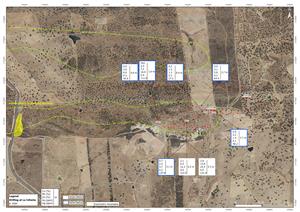
Figure 1: Plan map showing La Romanera drill hole locations
View Figure 1 here: https://www.globenewswire.com/NewsRoom/AttachmentNg/c93b48ce-b0ea-4b4b-950a-af371c4f015a
Figure 2: Vertical Longitudinal Section showing Upper Zone intercepts, La Romanera Deposit
View Figure 2 here: https://www.globenewswire.com/NewsRoom/AttachmentNg/a831b68e-5459-4f23-9afd-58802fe7a6b5
Figure 3: Vertical Longitudinal Section showing Lower Zone intercepts, La Romanera Deposit
View Figure 3 here: https://www.globenewswire.com/NewsRoom/AttachmentNg/6912b90d-3710-4beb-94e1-f86199f22dae
Table 1: Diamond drill hole data for La Romanera Deposit drilling
| DDH | Easting | Northing | Elevation | azimuth | dip | depth (m) | FROM | TO | Width (m) | Cu_% | Pb_% | Zn_% | Au_g/t | Ag_g/t | LENS |
| LR029 | 646593 | 4172590 | 148 | 191 | -66 | 403.7 | 338.0 | 342.7 | 4.8 | 0.3 | 0.3 | 0.7 | 0.44 | 35.0 | UL |
| LR029 | 379.8 | 384.7 | 4.9 | 0.8 | 0.2 | 0.5 | 0.22 | 13.3 | LL | ||||||
| LR067 | 646748 | 4172458 | 152 | 204 | -62 | 288.0 | 195.4 | 197.5 | 2.2 | 0.3 | 3.3 | 3.6 | 3.98 | 178.4 | UL |
| LR067 | 222.2 | 235.2 | 13.0 | 0.3 | 1.0 | 2.2 | 1.39 | 80.5 | LL | ||||||
| incl. | 230.2 | 234.2 | 4.0 | 0.3 | 1.4 | 3.7 | 2.16 | 81.0 | LL | ||||||
| LR069 | 646967 | 4172385 | 170 | 237 | -69 | 383.0 | 216.5 | 239.4 | 22.9 | 0.2 | 1.3 | 3.2 | 0.54 | 55.7 | UL |
| incl. | 235.0 | 238.9 | 3.9 | 0.2 | 3.3 | 8.6 | 0.50 | 88.5 | UL | ||||||
| LR069 | 294.8 | 302.1 | 7.3 | 0.1 | 1.0 | 1.5 | 1.60 | 39.7 | LL | ||||||
| LR076 | 646967 | 4172385 | 170 | 228 | -54 | 209.8 | 157.3 | 163.6 | 6.3 | 0.2 | 1.8 | 4.9 | 1.44 | 83.0 | LL |
| LR078 | 646335 | 4172525 | 138 | 238 | -72 | 231.6 | NO SIGNIFICANT INTERSECTS | LL | |||||||
| LR081 | 646660 | 4172585 | 152 | 194 | -46 | 351.0 | 260.2 | 267.7 | 7.5 | 0.3 | 0.5 | 1.1 | 0.70 | 26.3 | UL |
| LR081 | 297.7 | 325.7 | 28.0 | 0.5 | 1.1 | 3.0 | 1.82 | 43.3 | LL | ||||||
| LR083 | 646226 | 4172839 | 144 | 168 | -54 | 518.3 | NO SIGNIFICANT INTERSECTS | LL | |||||||
| LR089 | 646951 | 4172631 | 168 | 185 | -60 | 524.0 | 479.2 | 483.6 | 4.4 | 0.1 | 0.4 | 1.0 | 0.50 | 15.9 | LL |
| LR093 | 646817 | 4172418 | 150 | 163 | -70 | 340.6 | 180.0 | 184.5 | 4.5 | 0.2 | 2.1 | 6.5 | 2.83 | 117.5 | UL |
| LR093 | 279.8 | 283.5 | 3.7 | 0.3 | 0.8 | 2.4 | 0.99 | 46.8 | LL | ||||||
| LR097 | 646597 | 4172725 | 144 | 203 | -69 | 563.9 | 518.6 | 541.4 | 22.8 | 0.4 | 0.3 | 0.2 | 0.78 | 40.3 | LL |
| LR100 | 646811 | 4172660 | 152 | 163 | -56 | 511.6 | 461.7 | 465.1 | 3.4 | 0.7 | 0.2 | 0.8 | 0.23 | 3.5 | LL |
| LR101 | 646226 | 4172839 | 144 | 165 | -62 | 567.8 | 523.9 | 525.7 | 1.8 | 0.6 | 2.2 | 7.8 | 1.26 | 57.6 | LL |
| LR102 | 646951 | 4172631 | 168 | 185 | -67 | 570.8 | 501.7 | 504.9 | 3.2 | 0.1 | 0.4 | 1.2 | 0.49 | 13.1 | LL |
| LR104 | 646597 | 4172725 | 144 | 210 | -68 | 518.6 | 458.3 | 473.0 | 14.8 | 0.6 | 1.4 | 2.3 | 0.90 | 45.6 | UL |
| incl. | 462.2 | 467.2 | 5.0 | 0.3 | 3.5 | 6.0 | 1.07 | 71.0 | UL | ||||||
| LR104 | 486.9 | 490.8 | 3.9 | 0.5 | 0.3 | 0.5 | 0.44 | 32.3 | LL | ||||||
| LR115 | 646618 | 4172447 | 146 | 164 | -48 | 221.2 | 138.9 | 171.5 | 32.6 | 0.2 | 1.9 | 4.1 | 4.01 | 84.1 | LL |
| incl. | 155.0 | 158.5 | 3.5 | 0.1 | 2.3 | 3.4 | 7.07 | 99.9 | LL | ||||||
La Infanta
Assay results are included for holes IN060B, IN062B, IN063, IN064, IN065, IN066 and IN067 reported below (Figure 4 and Table 2).
A NI 43-101 mineral resource estimate for La Infanta is being completed concurrent with La Romanera deposit. La Infanta deposit is located about 7.0 km east of La Romanera. The El Cura deposit, which is located approximately midway between La Romanera and La Infanta will be drill tested later in 2023.
La Infanta deposit has 2 mineralized blocks, separated by a thrust fault (North and South Blocks), characterized by zinc, lead, silver and copper bearing massive sulphide mineralization. The mineralization has been tested by drilling from the surface to 350 m depth and for 1,400 m along strike. Mineralization remains open to the east and west. The best grades were found on the central part of the deposit which is 700 m long. Thicknesses vary from 3 to 6 m in both the North and South blocks. The average specific gravity is 3.1.
The 7 drill holes are part of the ongoing delineation program and were designed to intercept the South and/or North blocks. Drill hole IN067 intercepted mineralization as was projected, encountering very high grade polymetallic massive sulphide mineralization in both blocks. This drill hole has filled the gap between IN014 and IN021 (released on November 22, 2022 and January 28, 2023) and demonstrates this area remains open for additional drill testing at depth.
Drill Hole IN060B:
The North Block was intersected at 95.4 m down the hole and comprises 4.6 m of polymetallic mineralization grading 0.9 % Cu; 2.6 % Pb; 6.0 % Zn; 0.28 g/t Au and 43.0 g/t Ag, including 1.6 m grading 2.5 % Cu; 7.3 % Pb; 16.9 % Zn; 0.41 g/t Au and 111.0 g/t Ag).
Drill Hole IN062B:
No significant assays in this hole.
Drill Hole IN063:
No significant assays in this hole.
Drill Hole IN064:
The North Block was intersected at 166.7 m down the hole and comprises 8.4 m grading 0.2 % Cu; 1.5 % Pb; 1.3 % Zn; 0.25 g/t Au and 27.3 g/t Ag.
Drill Hole IN065:
The North block was intersected at 148.0 m down the hole and comprises 3.7 m grading 0.5 % Cu; 2.2 % Pb; 1.4 % Zn; 0.11 g/t Au and 40.2 g/t Ag.
Drill Hole IN066:
The North Block was intersected at 244.5 m down the hole and comprises 2.7 m of polymetallic mineralization grading 0.9 % Cu; 3.1 % Pb; 5.8 % Zn; 0.20 g/t Au and 64.4 g/t Ag.
Drill Hole IN067:
The North Block was intersected at 49.7 m down the hole and comprises 3.1 m of polymetallic mineralization grading 0.7 % Cu; 2.5 % Pb; 4.7 % Zn; 0.18 g/t Au and 137.9 g/t Ag. The South block was intersected at 108.2 m down the hole and comprises 6.5 m of massive sulphides grading 2.1 % Cu; 6.5 % Pb; 12.3 % Zn; 0.63 g/t Au and 214.5 g/t Ag. A second South Block zone was intersected at 149.2 m down the hole and comprises 5.3 m of massive sulphides grading 2.6 % Cu; 13.6 % Pb; 24.3 % Zn; 0.48 g/t Au and 131.4 g/t Ag.
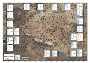
Figure 4: Plan map showing drill hole trace surface projections, La Infanta Deposit
View Figure 4 here: https://www.globenewswire.com/NewsRoom/AttachmentNg/d5e4c810-9ede-486f-a999-51e0570c9b69
Table 2: Diamond drill hole data, La Infanta Deposit
| DDH | Easting | Northing | Elevation | azimuth | dip | depth (m) | FROM | TO | Width (m) | Cu_% | Pb_% | Zn_% | Au_g/t | Ag_g/t | LENS |
| IN060B | 653707 | 4171616 | 204 | 172 | -50 | 277.0 | 95.4 | 100.0 | 4.6 | 0.9 | 2.6 | 6.0 | 0.28 | 43.0 | NB |
| incl. | 96.9 | 98.5 | 1.6 | 2.5 | 7.3 | 16.9 | 0.41 | 111.0 | NB | ||||||
| IN062B | 654572 | 4171828 | 190 | 172 | -50 | 257.0 | NO SIGNIFICANT INTERSECTS | ||||||||
| IN063 | 654226 | 4171709 | 204 | 172 | -50 | 251.0 | NO SIGNIFICANT INTERSECTS | ||||||||
| IN064 | 654142 | 4171696 | 209 | 172 | -50 | 271.0 | 166.7 | 175.1 | 8.4 | 0.2 | 1.5 | 1.3 | 0.25 | 27.3 | NB |
| IN065 | 654255 | 4171705 | 201 | 172 | -50 | 258.8 | 148.0 | 151.7 | 3.7 | 0.5 | 2.2 | 1.4 | 0.11 | 40.2 | NB |
| IN066 | 654134 | 4171755 | 203 | 172 | -50 | 325.0 | 244.5 | 247.3 | 2.7 | 0.9 | 3.1 | 5.8 | 0.20 | 64.4 | NB |
| IN067 | 653986 | 4171586 | 207 | 172 | -50 | 171.5 | 49.7 | 52.8 | 3.1 | 0.7 | 2.5 | 4.7 | 0.18 | 137.9 | NB |
| IN067 | 108.2 | 114.7 | 6.5 | 2.1 | 6.5 | 12.3 | 0.63 | 214.5 | SB | ||||||
| IN067 | 149.2 | 154.4 | 5.3 | 2.6 | 13.6 | 24.3 | 0.48 | 131.4 | SB | ||||||
Quality Assurance/Quality Control
Drilling at La Romanera and La Infanta is HQ size and core is placed into core trays at the drill site and transported directly from the site to Emerita’s coreshack (15Km) from La Romanera and (8Km) from La Infanta. Once the cores are received at Emerita's coreshack they are photographed and geotechnical logging is performed. Geological, mineralogical and structural logging follows and mineralized zones are identified. The samples are marked every 1m or less, and respecting lithological contacts, with most of the samples 1.0m long. The zone immediately above and below the mineralized zones are also sampled. Core samples are sawed in half and half of the core is returned to the core tray for future reference. Once the core samples are cut, bagged and tagged, they are shipped to the ALS laboratory in Seville by Emerita personnel where sample preparation is done. In Seville, ALS performs the mechanical preparation of the samples and then the pulps
are sent to ALS Ireland (ICP) and ALS Romania (fire assay). The analysis at ALS Lab corresponds to the ME-ICPore (19 elements) package, together with the Au-AA23 fire assay (Gold).
10% of the analyzed samples correspond to control samples (fine blanks, coarse blanks, high, medium and low grade standards). In addition, 10% of pulps are reanalyzed at a second independent certified laboratory (AGQ Lab Sevilla). When the analysis is completed, the certificates are received from the laboratory and the QA/QC protocol identifies any deviation or anomaly in the results and the entire batch is reassayed in such case. Once the data is approved by the QA/QC protocol assays are entered digitally directly into the database.
Qualified Person
The scientific and technical information in this news release has been reviewed and approved by Mr. Joaquin Merino, P.Geo., President of the Company and a Qualified Person as defined by NI 43-101 of the Canadian Securities Administrators.
About Emerita Resources Corp.
Emerita is a natural resource company engaged in the acquisition, exploration and development of mineral properties in Europe, with a primary focus on exploring in Spain. The Company’s corporate office and technical team are based in Sevilla, Spain with an administrative office in Toronto, Canada.
For further information, contact:
Vincent Chen
+1 778 990 9433 (Toronto)
info@emeritaresources.com
Cautionary Note Regarding Forward-looking Information
This press release contains “forward-looking information” within the meaning of applicable Canadian securities legislation. Forward-looking information includes, without limitation, the mineralization of the IBW Project; the timing of assay results; the prospectivity of the Project; the timing and ability of the Company to produce an NI 43-101 compliant mineral resource estimate and the Company’s future plans. Generally, forward-looking information can be identified by the use of forward-looking terminology such as “plans”, “expects” or “does not expect”, “is expected”, “budget”, “scheduled”, “estimates”, “forecasts”, “intends”, “anticipates” or “does not anticipate”, or “believes”, or variations of such words and phrases or state that certain actions, events or results “may”, “could”, “would”, “might” or “will be taken”, “occur” or “be achieved”. Forward- looking information is subject to known and unknown risks, uncertainties and other factors that may cause the actual results, level of activity, performance or achievements of Emerita, as the case may be, to be materially different from those expressed or implied by such forward-looking information, including but not limited to: general business, economic, competitive, geopolitical and social uncertainties; the actual results of current exploration activities; risks associated with operation in foreign jurisdictions; ability to successfully integrate the purchased properties; foreign operations risks; and other risks inherent in the mining industry. Although Emerita has attempted to identify important factors that could cause actual results to differ materially from those contained in forward-looking information, there may be other factors that cause results not to be as anticipated, estimated or intended. There can be no assurance that such information will prove to be accurate, as actual results and future events could differ materially from those anticipated in such statements. Accordingly, readers should not place undue reliance on forward-looking information. Emerita does not undertake to update any forward-looking information, except in accordance with applicable securities laws.
NEITHER TSX VENTURE EXCHANGE NOR ITS REGULATION SERVICES PROVIDER (AS THAT TERM IS DEFINED IN THE POLICIES OF THE TSX VENTURE EXCHANGE) ACCEPTS RESPONSIBILITY FOR THE ADEQUACY OR ACCURACY OF THIS RELEASE.


Figure 1
Plan map showing La Romanera drill hole locations
Figure 2
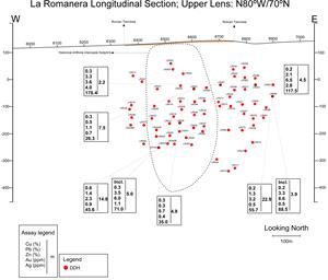
Vertical Longitudinal Section showing Upper Zone intercepts, La Romanera Deposit
Figure 3
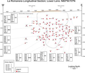
Vertical Longitudinal Section showing Lower Zone intercepts, La Romanera Deposit
Figure 4