Savary Gold Provides Exploration Update
(TheNewswire)
Toronto, Canada / TheNewswire / February 15, 2017 - Savary Gold Corp. (TSX-V: SCA) ("Savary" or the "Company") is pleased to provide an exploration update for the ongoing Karankasso JV exploration Project in south western Burkina Faso. At year-end 2016, upon closing, it is anticipated that the Karankasso JV Project is approximately 69.5% owned by Savary and 30.5% owned by Sarama Resources Limited ("Sarama") with Savary as operator.
In addition to 22 holes of drilling completed in December, 2016, (see Savary news release January 17, 2017), since late October 2015, Savary, on behalf of the Karankasso JV, has completed, 9,211 metres of auger drilling in 1,381 holes, 275 line kilometres of IP gradient geophysical surveys and collected 5,231 soil samples. The Karankasso JV is pleased to announce that the current drill program, which commenced in late January, 2017 has already completed 28 holes totalling 2,663 metres or approximately 27 % of the planned, approximately 10,000 metre, Q1, 2017, drill program. Assays are pending. This is the largest program completed to date on the Karankasso Project and has led to the development of numerous drill targets and potential targets.
"The current drill program is designed to build on our current inferred mineral resources of 671,000 ounces grading 2.28 g/t Au* and actively explore for new zones, especially on the southern portion of the project area. Exploration on the southern portion of the property had identified numerous areas with significant amounts of gold mineralization with recent geophysical and auger surveys providing context to the historic results. Follow-up drill testing is currently being carried out." stated Don Dudek, President and CEO of Savary. Mr. Dudek further noted that "We are optimistic that drilling will not only extend the existing gold zones, but, also will lead to the discovery of new zones that will have the potential for defining new resource zones."
* Mineral resource estimate presented in Savary news release dated October 8, 2015
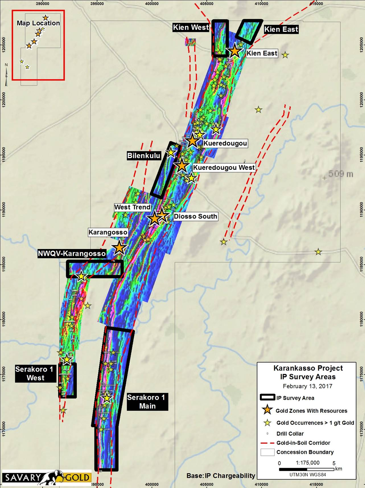
IP gradient geophysical surveys were carried out over 6 areas: Serakoro 1 Main, Serakoro 1 West, Karangosso-NWQV zone link, Bilenkulu zone area, Kien East northern extension and Kien West northern extension (see Figure 1).
Serakoro 1 Main Area
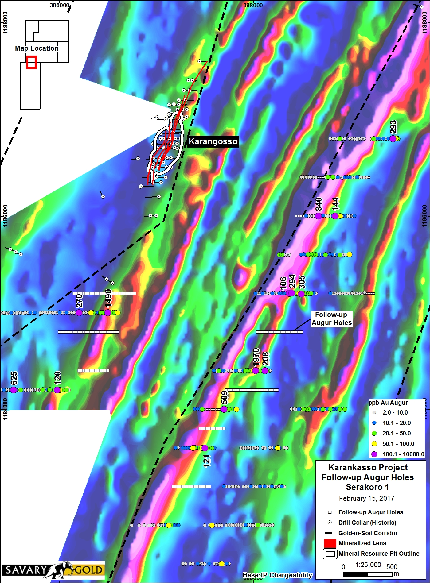
The largest survey area, Serakoro 1 Main, was designed to trace the central mineralized trend from the Diosso South Zone area (0.82 million tonnes grading 2.93 g/t gold*) to the Serakoro 1 Main zone area, where previous drilling had returned up to 2.66 g/t gold over 10 metres. This survey successfully extended the control shear/alteration structure another 13 kilometres to the south, for a currently traceable distance of approximately 43 kilometres (see Figure 1). In conjunction with this survey, 530 auger drill holes totalling approximately 3,700 metres were completed in select localities along a 13.5 kilometres long gap between the southernmost Diosso South Zone holes and the northernmost Serakoro 1 Main area, where overburden masked the bedrock response. The combination of the geophysical, auger and soil survey data has led to the delineation of a 3.9 km long untested target area (see Figure 2) immediately adjacent to the same geophysical feature that hosts and links the Diosso South, West Trend, Kueredougou West and Kueredougou Main zones, all of which contained inferred mineral resources. In-fill auger drilling and drill testing of this target area, which returned the highest gold-in-auger value of 1,970 ppb gold, has been recommended by Savary the Operator.
Click Image To View Full Size
Figure 1 - 2016-17 IP Geophysical Survey Blocks
Click Image To View Full Size
Figure 2 - Main Trend - Significant gold-in-auger anomalies on color-contoured geophysical base
Serakoro 1 West Target Area
The Serakoro 1 West area is a 3.6-kilometre long by 1.2-kilometre wide area where previous drilling returned intercepts of up to 6.42 g/t gold over 15 metres, 18.72 g/t gold over four metres, 8.74 g/t gold over six metres and 2.8 g/t gold over 12 metres. During the current exploration program, the southern half of this area was covered by 24 line kilometres of IP gradient geophysical surveys and 255 auger drill holes. The results of this work, have delineated several high-quality drill targets with gold-in-auger highs following the flanks of distinct chargeability geophysical anomalies (see Figure 3). The chargeability anomalies show three structural orientations with north-northeast, north-northwest and northeast trends. Multiple structural directions with coincident gold-in-auger values, are deemed positive exploration targeting features. Follow-up drilling has been carried out with assay results pending.
Karangosso-NWQV Zones link area
Recent IP gradient geophysical surveys (32-line kilometres) and 308 auger drill holes have been carried out between the Karangosso and the NWQV Zones, which have been inferred to be structurally linked. While the new data does not support structurally linking the two zones, five gold-in-auger anomalies were delineated with the best anomaly returning 1,490 ppb gold, which in management's view suggests that the auger hole drilled directly into a gold zone (see Figure 2). This strong gold-in-auger anomaly lies along a 900-metre long, distinct, resistivity and chargeability geophysical anomaly near the eastern edge of the southern projection of the Karangosso Zone felsic intrusion host. Since the initial auger lines were 800 metres apart, in-fill auger holes have been drilled; assays are pending.
Auger Drilling
Vertical auger holes were planned over overburden-covered areas where soil sampling has been ineffective. Auger holes range from 3 to approximately 21 metres deep with an average of 6.7 metres deep. Auger lines in select areas, varies from 400 to 800 metres apart with auger stations every 25 metres. Two auger samples are collected in each hole comprising, basal laterite, which is considered a mobile layer and the adjacent saprolite, which is inferred to represent the top of the weathered rock profile. As a back-up, a representative sample, for every metre down-hole, is collected and placed into chip trays. While it is ideal to intersect gold values in the saprolite, which means that the auger hole intersected a gold zone, the odds are the hole will miss. This is why the basal laterite samples are collected and analysed; this horizon can pick up gold from a nearby gold zone that wasn't intersected in the auger hole.
Gold-in-auger values greater than 200 ppb gold are considered significant with auger values above 30 ppb gold sufficient for delineating mineralized trends. Management believes that the highest value obtained from the current survey of 1,970 ppb gold, likely indicates that the auger hole intersected the upper portions of the gold zone.

Click Image To View Full Size
Figure 3 - Serakoro 1 West Area - Auger, Geophysics and Historic Drilling
Continue Drill Target Development
Soil assay data has defined strongly anomalous gold-in-soil values outside of the current drill target areas. More work will be required to develop drill targets over these recently discovered gold-in-soil anomalies.
QA/QC Comments
Savary's procedure for handling auger samples comprises initial riffle splitting of the auger samples from one metre drill length samples into approximately 2.5-kilogram samples, as well as description and logging into a database. These samples are then presented to Savary personnel where QA/QC standards, blanks and duplicates are inserted into the sample stream, representing 4% of the samples. These samples are then collected on site, or delivered directly to Activation Laboratories in Ouagadougou, Burkina Faso where they are subjected to BLEG analysis of the entire sample.
Soil samples are collected in the field along 400 metre spaced lines with stations every 25 metres. Each sample site is excavated with picks and shovels to a depth of approximately 50 cm. Material from this depth are sieved with a 1mm mesh screen with approximately 0.6 to 0.7 kg of sample collected for each station. QA/QC standards, blanks and duplicates are inserted into the sample stream, representing 6% of the samples. These samples are then collected on site, or delivered directly to Activation Laboratories or SGS Laboratories in Ouagadougou, Burkina Faso where they are subjected to BLEG analysis of the entire sample.
Savary is a Canadian exploration company which, along with anticipated JV partner Sarama Resources Limited, is focused on exploring and developing the Karankasso Gold Project in Burkina Faso. The Project is located within the Birimian age, Hound?(C) Greenstone Belt, which hosts Semafo's Mana mine, Roxgold's Yaramoko Mine and additional gold deposits that are presently subject to production decisions and extensive exploration efforts (including Endeavour Mining's Hound?(C) Project, Orezone's (acquired by Sarama) Bondi Project and Sarama's/Acacia's South Hound?(C) Project, which is adjacent to Savary's property). The Project contains an Inferred open pit constrained mineral resource estimate of 9.16 million tonnes grading 2.28 g/t gold* (Savary news release November 24, 2015). For additional information please visit our website at www.savarygold.com.
Don Dudek, P.Geo., President and CEO of the Company and a qualified person under National Instrument 43-101, has reviewed and approved the scientific and technical information in this press release.
SAVARY GOLD CORP.
On behalf of the Board
"Don Dudek"
President & Chief Executive Officer
For more information, please contact:
Don Dudek, President and CEO
T: 647-259-2097
E: info@savarygold.com; www.savarygold.com
Cautionary Notes
Neither TSX Venture Exchange nor its Regulation Services Provider (as that term is defined in the policies of the TSX Venture Exchange) accepts responsibility for the adequacy or accuracy of this release.
This news release may contain forward-looking statements. These statements include statements regarding the details of the potential value growth of the JV, the upside of the property, the drill program, the company's exploration plans and the timing of results, the focus on existing drill targets and new targets. These statements are based on current expectations and assumptions that are subject to risks and uncertainties. Actual results could differ materially because of factors discussed in the management discussion and analysis section of our interim and most recent annual financial statement or other reports and filings with the TSX Venture Exchange and applicable Canadian securities regulations. We do not assume any obligation to update any forward-looking statements, except as required by applicable laws.
Copyright (c) 2017 TheNewswire - All rights reserved.