VR commences Phase II drilling at its Reveille silver-copper property in Nevada
VANCOUVER, British Columbia, June 29, 2021 (GLOBE NEWSWIRE) -- VR Resources Ltd. (TSX.V: VRR, FSE: 5VR; OTCBB: VRRCF), the "Company,” or “VR,” is pleased to provide an update on the ongoing exploration at its Reveille silver-copper and gold property in the Walker Lane gold-silver mineral belt in west-central Nevada.
Phase II drilling is underway
In follow-up to results from the completion of 5 drill holes in March and in May for Phase I of the Reveille drill program, Phase II drilling is now underway. Four drill holes, each from 1,000 – 1,500 feet deep, are planned:
- Photo 1 shows the drill late last week set up on the first hole.
- Figure 1 shows the location of all completed and planned drill holes for Phase I and II, respectively, on an 3D DCIP iso-shell geophysical basemap which shows the new, large Kawich IP anomaly.
Two drill holes are planned to test the roots of the breccia pipe at G1 intersected in over 100 m of drill core in the final hole of the Phase I program, and two holes are planned to test the core of the new IP anomaly at Kawich. The program is expected to take 2 – 3 weeks to complete, with geochemical results anticipated by the end of the summer, including complete hyperspectral scanning of drill chips for alteration mineral mapping.
Expansion of 3D array DCIP survey is complete and Kawich anomaly is confirmed
The expansion of the 3D array DCIP ground-based geophysical survey is complete and final, processed data are in hand. The large and high amplitude (>30mV/V) IP anomaly at Kawich that was announced and described in detail in the previous News Release dated May 19th is both confirmed, and refined:
- Figure 1 shows the three dimensional outline of the entire chargeability anomaly in plan view;
- Figure 2 shows the correlation of the chargeability anomaly within the strongly structurally controlled resistivity iso-shells.
As explicitly implied in Figure 2, the Kawich IP anomaly provides a specific target for a large sulfide concentration formed at the potential source of the overall polymetallic mineral system at Reveille. This target has never been explored or drilled during the 140 years of historic prospecting in the Reveille range to the east. Importantly:
- the IP anomaly is on trend with the northeast-trending structure which controls silver-copper mineralization at the various showings exposed at surface in the hills of the Reveille range to the east;
- The IP anomaly is shallow, with a depth to top of < 150m; it is constrained by a cap of volcanic rocks;
- The IP anomaly correlates with anomalies in both the magnetic and resistivity data derived from the independent airborne VTEM+ survey completed in 2020.
The IP anomaly is near the margin of the Kawich caldera. The high grade silver-copper showings and historic workings exposed at surface in the Reveille range to the east are believed to be distal expressions of a hydrothermal fluid system centered on the Kawich IP anomaly and anchored by the deeply seated structures of the Kawich caldera. Support for this model from new drill data is provided in the next section.
Geochemistry from Phase I RC drilling
A fence of four scout RC drill holes totaling more than 1,325 metres was completed for Phase I in March (Figure 1). They targeted magnetic, EM and gravity features along northeast trending structures mapped in the field which silver-copper mineralization and jasperoid formation in the Reveille range to the east (Figure 2). All geochemistry is now in hand from more than 800 samples from the continuous sampling of each drill hole in its entirety. Also, long-wave and short-wave infrared (LWIR and SWIR) hyperspectral scanning was completed on drill chips for the entire length of each hole in order to map alteration minerals.
The drill holes did not intersect material concentrations of silver or copper; however, high temperature base metal zonation and trace element indicators including Cu-Mo-W-Tl-Zn-Sb-As provide a clear and robust vector within the carbonate host rocks in the hills towards the Kawich IP anomaly in the valley, and a proximal source area to the Reveille CRD/porphyry system overall.
- Figure 3 shows the clear increase in copper + molybdenum concentrations at the base of andesite towards the Kawich IP anomaly, a proxy for temperature gradient and proximity to an intrusive source;
- Figure 4 shows the increase in silica and high temperature potassic clay alteration in Holes 1 and 2 which are located the closest to the northeastern margin of the large IP anomaly.
As illustrated in Figure 3, it is clear that alteration mineral intensity tracks outwards and away from the IP anomaly along the lower contact of the highly impermeable volcanic cap rock covering the valley and intersected in the upper part of three of four drill holes.
The drill data support the key spatial relationship shown in Figure 2; the Kawich IP anomaly is at the southwest end of the northeast-trending structure mapped in the field by VR which controls the formation of extensive jasperoid at G1 and the specific sites of high grade silver-copper mineralization at the historic workings at Zebra. The highest temperatures alteration (muscovite) is evident along this structure in Hole 1, whereas in Hole 2, collared roughly 150m southeast of the structural corridor, the intense silica replacement and base metal geochemistry are indicative of proximity to the Kawich IP anomaly.
CEO Comment
From VR’s CEO, Dr. Michael Gunning, “For our shareholders who have been following Reveille for the past year and who know that our goal has been to apply modern mineral deposit models and new exploration technologies to look for the center of the overall CRD/porphyry mineral system at Reveille, and we believe the large and data-robust IP anomaly in Figure 1 is exactly that.
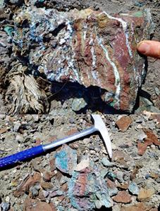
Take a moment to look at Photo 2 at the end of this news release. It shows the intense alteration mapped at surface in volcanic rocks forming the valley cover immediately above and adjacent to the Kawich IP anomaly. This alteration, in conjunction with the new geochemical data from Phase I drilling underscores the potential that the Kawich IP anomaly is a sulfide concentration in the proximal, high temperature core to the overall polymetallic hydrothermal fluid system this is responsible for the distal but high grade showings scattered in the hills to the east.
We look forward to providing further updates as our drilling advances and new geochemical data are received through the summer.”
Technical Information
Summary technical and geological information for the Company’s various exploration properties is available at the Company’s website at www.vrr.ca.
VR submits all surface grab samples and/or drill core samples collected from Nevada-based exploration projects for geochemical analysis to the ALS Global (“ALS”) laboratory in Reno, Nevada. Sample preparation is completed in Reno. Analytical work includes ICP-MS analyses for base metals and trace elements completed at the ALS laboratories located in Vancouver, BC., and gold determination by fire assay atomic absorption spectrometry completed at facilities in Reno, Nevada. Analytical results are subject to industry-standard and NI 43-101 compliant QAQC sample procedures at the laboratory, as described by ALS, and with standard, duplicate and blank samples inserted internally by VR.
Technical information for this news release has been prepared in accordance with the Canadian regulatory requirements set out in National Instrument 43-101. Justin Daley, P.Geo., Exploration Manager & Chief Geologist at VR and a non-independent Qualified Person oversees and/or participates in all aspects of the Company’s mineral exploration projects and has reviewed the content of this news release. The Company’s CEO, Dr. Michael Gunning, P.Geo., is also a non-independent Qualified Person.
About the Reveille Property
The Reveille property is located approximately 90 km’s east of Tonopah, Nevada. Access is via Highway 6, with local roads and trails in and around the property itself.
The Reveille property consists of 93 mineral claims in one contiguous block covering 1,586 acres (642 hectares) over an area of approximately 2 x 3 km’s. The property is on federal land administered by the BLM, and are outside of the BLM’s broadly defined area of sage grouse protection. There are no underlying annual lease payments on the property, nor are there any joint venture or carried interests on the property. There is an industry-standard royalty attached to the property, with a standard buy-back provision to VR.
About VR Resources
VR is an established junior exploration company focused on greenfields opportunities in copper and precious metals (TSX.V: VRR; Frankfurt: 5VR; OTCBB: VRRCF). VR is the continuance of 4 years of active exploration in Nevada by a Vancouver-based private company. The diverse experience and proven track record of its Board in early-stage exploration, discovery and M&A is the foundation of VR. The Company focuses on underexplored, large-footprint mineral systems in the western United States and Canada, and is well financed for its exploration strategies and corporate obligations. VR owns its properties outright, and evaluates new opportunities on an ongoing basis, whether by staking or acquisition.
The Company continues its normal course of business in 2021 within the framework of modified exploration programs in response to the COVID-19 pandemic, with the goal of ensuring the health and safety of staff and project personnel.
ON BEHALF OF THE BOARD OF DIRECTORS:
“Michael H. Gunning”
____________________________
Dr. Michael H. Gunning, PhD, PGeo
President & CEO
For general information please use the following:
| Website: | www.vrr.ca |
| Email: | info@vrr.ca |
| Phone: | 604-262-1104 |
Forward Looking Statements
This press release contains forward-looking statements. Forward-looking statements are typically identified by words such as: believe, expect, anticipate, intend, estimate, postulate and similar expressions or are those which, by their nature, refer to future events. Forward looking statements in this release include “Phase I drilling underscores the potential that the Kawich IP anomaly is a sulfide concentration in the proximal, high temperature core to the overall polymetallic hydrothermal fluid system”, “The program is expected to take 2 – 3 weeks to complete”, and “VR evaluates new opportunities on an ongoing basis, whether by staking or acquisition.”
This news release contains statements and/or information with respect to mineral properties and/or deposits which are adjacent to and/or potentially similar to the Company’s mineral properties, but which the Company has no interest in nor rights to explore. Readers are cautioned that mineral deposits on adjacent or similar properties are not necessarily indicative of mineral deposits on the Company’s properties.
Although the Company believes that the use of such statements is reasonable, there can be no assurance that such statements will prove to be accurate, and actual results and future events could differ materially from those anticipated in such statements. The Company cautions investors that any forward-looking statements by the Company are not guarantees of future performance, and that actual results may differ materially from those in forward-looking statements. Trading in the securities of the Company should be considered highly speculative. Readers are urged to review all of the Company’s public disclosure filings available at www.sedar.com.
Neither the TSX Venture Exchange nor its Regulation Services Provider (as that term is defined in Policies of the
TSX Venture Exchange) accepts responsibility for the adequacy or accuracy of this release
Photos accompanying this announcement are available at
https://www.globenewswire.com/NewsRoom/AttachmentNg/a40d1827-ecf7-4f3d-8d84-64ded3ecbac9
https://www.globenewswire.com/NewsRoom/AttachmentNg/42178582-5c9d-4727-a31e-55e924aa5f1f
https://www.globenewswire.com/NewsRoom/AttachmentNg/e5dc9037-f121-4001-911e-b2798a6f68da
https://www.globenewswire.com/NewsRoom/AttachmentNg/4cac0766-0af4-4b9e-ab3b-5f982bab57d8
https://www.globenewswire.com/NewsRoom/AttachmentNg/6a02a5c1-e59c-43fa-88a4-18cb774cbf11
https://www.globenewswire.com/NewsRoom/AttachmentNg/11c982f9-e72a-4e4c-83fb-64aa72346d38
![]()
Photo 1.
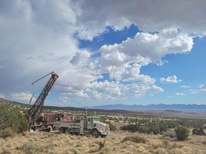
The truck-mounted RC drill rig set up on drill hole RV21-006 on June 24, 2021. The drill mast is pointing northeasterly to test the roots of the G1 breccia pipe intersected in more than 100 m of drill core in drill hole RV21-005 completed in May and located approximately 150 metres away, up the lower flank of the ridge. Behind the drill in this photo is the Kawich IP anomaly to be drilled later in the program; it is under valley cover and previously unexplored.
Figure 1.
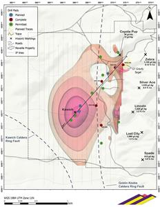
A 3D iso-shell image of the large and high amplitude (32 mV/V) DCIP anomaly at Reveille derived from the inversion of new data following completion in May of an expansion of survey originally completed in March. Shown are the 5 drill holes completed to date at Reveille by VR, and the four drill holes planned for the current program (blue): two into the roots of the breccia pipe at G1, and two into the core of the new IP anomaly.
Figure 2.
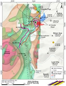
Location of the Kawich IP anomaly within a structurally controlled IP-resistivity halo. Assays shown at workings are from VR sampling in June, 2020. The two dashed lines outline the northeast-southwest fold axis mapped by VR which controls silver-copper mineralization at the historic showings in the hills; the new IP anomaly is at the southwest end of the structural corridor, and proximal to the eastern margin of the Kawich Caldera.
Figure 3.
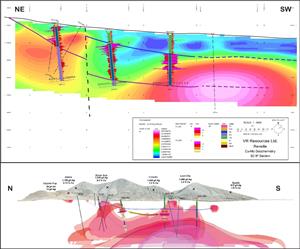
Select drill hole geochemical data from Phase I drilling complete in March, 2021, shown in relation to the new Kawich IP anomaly shown in plan view in Figure 2. The data provide a clear vector towards the Kawich IP anomaly as a proximal source area to the Reveille system based on high temperature trace element and base metal indicators, and on the intensity of alteration mineral assemblages. The top graphic shows the base metal indicators copper and molybdenum, and the lower graphic shows the high temperature trace element indicator thalium. A northeast-trending structural corridor mapped on surface by VR and shown in plan view on Figure 2 provides the control for the conduit of mineralizing fluids shown by the yellow block area in the lower panel of this figure.
Figure 4.
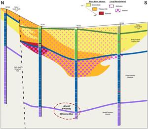
Alteration mineral mapping in Phase I RC holes using continuous hyperspectral scanning of drill chips. There is a clear temperature gradient zonation from SWIR mineral picks of lower temperature montmorillonite into potassium-illite and crystalline muscovite as well as LWIR observed silica replacement nearer to the Kawich IP anomaly and the structures that accommodate it. The rock photos on the following page provide support for this vector towards Kawich: intense iron, silica and potassium alteration mapped at surface in the volcanic rocks which form the valley cover immediately above the IP anomaly.
Photo 2.